A new tropical storm was expected to form Monday in the Caribbean and eventually threaten parts of the US south-east, forecasters said.
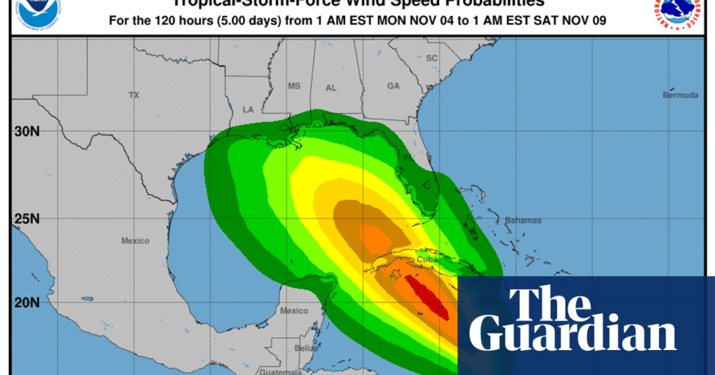
Expected to be named Rafael, the storm will bring heavy rain to Jamaica and the Cayman Islands before strengthening to a hurricane and probably hitting Cuba. Forecasters are predicting that it will bring heavy rainfall to parts of the US along the Gulf of Mexico, according to advisories from the Miami-based National Hurricane Center (NHC).
A tropical storm warning was in effect for Jamaica and a hurricane watch was in effect for the Cayman Islands.
“Potential Tropical Cyclone 18” on Monday morning was located about 220 miles (355km) south of Kingston, Jamaica. The storm had maximum sustained winds of 35mph (55km/h) while moving north at 7mph, the center said.
The storm was expected to move near Jamaica by late Monday and be near or over the Cayman Islands late Tuesday into Wednesday. It could be near hurricane strength when it passes near the Cayman Islands.
The most recent forecast shows the storm could pass over western Cuba on Wednesday as a hurricane. People in Cuba and the Florida Keys were among those urged to monitor the storm as it develops.
While weather models suggest the center of the storm could eventually make landfall between Louisiana and the western edge of the Florida panhandle, dry air and water temperatures in the 70s Fahrenheit could cause it to rapidly weaken as it moves north.
Heavy rainfall will affect the western Caribbean with totals of 3 to 6in (7 to 15cm) and up to 9in expected locally in Jamaica and parts of Cuba. Flooding and mudslides are possible.
Annually, hurricane seasons are expected to last at least through 30 November. Hurricanes forming in the late stages of those seasons has been seen more often during the ongoing climate crisis, spurred primarily by the burning of fossil fuels.
On the opposite side of the Atlantic Ocean, Tropical Storm Patty was forecast to become a post-tropical cyclone on Monday. The storm was about 490 miles east of the Azores, with maximum sustained winds of 40 mph. There were no coastal watches or warnings in effect.
The Associated Press contributed to this report

